- Undergraduate
- Research
- Off-Campus Study
- News & Events
- People
Back to Top Nav
Back to Top Nav
The deaths in the Texas Hill Country are a tragic testament to the force of a raging river. Flood-stricken Vermont has a radical plan to counter the threat it faces.
Access Original Articler HERE
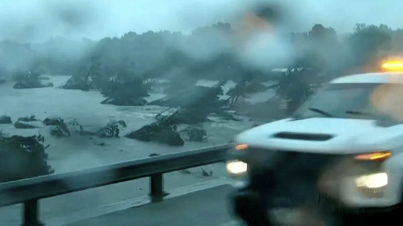
On the evening of July 3rd, as the sun went down over Kerrville, Texas, a small city of some twenty-five thousand people and the seat of Kerr County, the water in the Guadalupe River was just four inches deep, according to the U.S. Geological Survey's stream gauge there. The area hadn't had any rain since mid-June. R.V. campers in the HTR TX Hill Country campground in Kerrville, some of whom had arrived at the sixty-five-acre facility only hours before, could barely hear the river, even though they were parked in premium spots next to it.
At 3:30 A.M. on July 4th, Dalton Rice, the city manager, went out for an early-morning jog along the sluggish waterway. The river had risen to 1.71 feet, around the average depth. Kerrville's much anticipated "Fourth on the River" celebration at the riverside Louise Hays Park was scheduled for that afternoon, and Rice saw "not a drop of rain" during his run, he later told Dan Patrick, the lieutenant governor of Texas. By 4 A.M., when Rice went home, "there was very light rain," he said that day. "We did not see any signs of the river rising at that time."
Rice was apparently unaware that a few hours earlier, at 1:14 A.M., the Austin-San Antonio office of the National Weather Service had sent a flash-flood warning for south-central Kerr County. The area it covered included the town of Hunt, about twelve miles upstream from Kerrville, where Camp Mystic, a girls' sleepaway camp, was situated, at the confluence of Cypress Creek and the south fork of the Guadalupe. At 4:03 A.M., the warning was upgraded to an emergency: "This is a PARTICULARLY DANGEROUS SITUATION. SEEK HIGHER GROUND NOW!" The stream gauge at Hunt showed the river nearing twenty-two feet, twelve feet higher than its banks. In the next hour, it would rise to thirty-seven feet, at which point the gauge stopped transmitting.
Network-news footage of flood-related disasters has traditionally shown low-lying coastal towns swamped by storm surges from named weather systems, with residents and rescue workers navigating the streets in hip waders, canoes, and powerboats, and the water level sometimes taking days to subside. Houston, New Orleans, Tampa, Charleston, and New York are among the cities that have been inundated in the past three decades. Yet storm-surge-driven inundation flooding is not the deadliest kind of flood. The disaster often unfolds slowly enough that there's time for many people to get to higher ground—and for weather reporters to get in place. The water isn't moving anywhere near as fast as that of a flooded river. The flowing water in a mad river reshapes the entire landscape, a process known as fluvial erosion.
The flood barrelling down on Kerr County more resembled a tornado or a wildfire, a volatile, rapidly changing hazard, with a narrow window within which to act before the deadly force of the raging river arrived at your door. The September, 2024, floods that killed a hundred and eight people in the high country of western North Carolina, when Hurricane Helene passed over, were this kind of event, as were the floods in Valencia, Spain, in late October, 2024, which killed two hundred and thirty-two people. The recent flooding in Ruidoso, New Mexico, which claimed three lives, was, too. In my part-time home of Vermont, storms flooded much of the state, including the capital, Montpelier, in July, 2023, and flooding caused by the remnants of Hurricane Beryl hit the town of Plainfield, among other places, in July, 2024. Two people died in each event, and the damage from erosion was severe. The 2023 disaster wasn't even caused by a named storm. Rain-soaked "thunder boomers" were enough to do the damage.
Historically, this kind of flooding, which often occurs in hilly and mountainous regions, has received far less attention than storm-surge flooding, and local municipalities tend to be less prepared than coastal towns to deal with it. People who have moved away from the beach to escape hurricanes and rising sea levels, and have settled in supposed "climate havens" like Asheville, North Carolina, or Plymouth, Vermont, are reluctant to accept that they have merely traded a devil they know for one they don't. Francis J. Magilligan, a fluvial geomorphologist at Dartmouth College, told me, "We are actually getting pretty good at figuring out inundation risk. I would say, comparatively, we're at the starting point of thinking about erosional risk. And we don't have a good set of tools, FEMA or otherwise, to understand that risk."
The floodplain maps that the Federal Emergency Management Agency uses to designate a Special Flood Hazard Area, or S.F.H.A., are based on historical climate and geological data. The maps don't show the actual boundaries of past floods; rather, they illustrate statistical constructs based on the probability that a flood of a certain magnitude will occur there in a certain time range. The National Flood Insurance Program uses the maps to calculate risk. People who live in a hundred-year floodplain, for example, have a one-per-cent chance of being flooded in any given year. Anyone who builds or buys property in a mapped floodplain must take out federal flood insurance in order to qualify for a mortgage. The maps cover the coastal areas and the borders of major rivers, like the Mississippi, that flood frequently. They often don't cover mountainous communities with smaller rivers and streams, where flooding can affect not only people living down by a river but also those living on banks high above it, whose homes may be lost to erosion. Moreover, most of the data FEMA uses to designate S.F.H.A.s are based on readings from the nineteen-sixties and earlier—data that climate change has largely rendered obsolete. The language, too, engenders a false sense of confidence. It makes it sound as though a bad flood will occur only once every hundred years, and that's not the way the statistic is supposed to work.
Flash floods often occur in terrain with steep, narrow valleys that drain into rivers where the water is confined in natural and man-made channels and has nowhere else to go. The trigger is very heavy, concentrated rainfall. Warmer oceans lead to more surface evaporation, and warmer air is capable of carrying more moisture. When the warm air is forced upward by mountains, it cools and loses its ability to retain water, causing a sudden release of rain. With the Valencia floods, a year's worth of rain fell in a single day. In North Carolina, upward of twelve to fourteen inches of rain fell in several hours. As global temperatures rise, outbursts of extreme precipitation will increase. Carl Renshaw, a hydrologist at Dartmouth, told me, referring to the meteorological conditions that led to the Texas floods, "You're dumping so much water so quickly because you've primed the system with moisture. It's like loading a gun. The people there had no time."
Kerr County and its neighbor Kendall County sit in a valley that is known as Flash Flood Alley, because of the speed with which rainfall runs off the cliffs of the Balcones Escarpment and sluices down through streams and rivers to the coastal plain around San Antonio. The hillsides are steep, and the thin, dry topsoil over bedrock retains little water. Major flooding occurs regularly. And yet, even in Flash Flood Alley, which the judge of Kerr County, Rob Kelly, described in a press conference on July 4th as "the most dangerous river valley in the United States," people continue to build in hundred-year floodplains. When properties are flooded, old-timers and newcomers alike tend to fix things back up. Kimberly Meitzen, a geography professor at Texas State University, in San Marcos, a small city in the Guadalupe River basin, told me, "We have this history of flooding and rebuilding here." She mentioned five floods within living memory, in 1978, 1987, 1998, 2002, and 2015, in which not just houses but whole neighborhoods were washed away. "They just rebuild," she said. Moreover, she added, "people continue to request variances to rebuild even closer" to the river. "There's no really strong regulatory authority to prevent it," she went on. "And so it just continues to put more people at risk."
In Vermont, a flood in August, 2011, caused by Hurricane Irene, was so devastating that the U.S. Geological Survey called it a five-hundred-year flood, and at least one analysis deemed it a thousand-year flood. The flood that tore through Plainfield on July 10, 2024, occurred one year to the day after the 2023 flood, which had been a hundred-year one. And, on the same day this July, a violent flood struck Caledonia County, in the north of the state. Although such a tight grouping of floods isn't statistically impossible, it suggests that the probability curves used by FEMA are out of whack with real climate conditions.
A recent national study commissioned by First Street Foundation, a private risk-assessment firm, concluded that floods previously considered to be hundred-year events have become, on average, sixty-two-year events. (In some places, the estimate is as low as eight years.) The study also found that in Vermont's Washington County, which includes Montpelier, Plainfield, and the city of Barre, more than forty-eight hundred properties (out of nearly thirty thousand total properties) are at high risk of flooding, yet FEMA includes fewer than fifteen hundred of those properties on its special-flood-hazard maps. Nationally, the study found that 17.7 million properties are at risk of flooding, but only about five million properties are in a FEMA flood-hazard zone. That means that millions of home buyers and owners are making decisions with an incomplete understanding of the true physical and financial risks they face. Jeremy Porter, the head of climate-implications research at First Street, told me, "Ultimately, what you end up doing is systematically underestimating flood risk."
Vermont feels like the frontier of climate change in the Northeast. Farmers in the bottomlands, who previously planted wheat and barley, are beginning to plant rice, which can be underwater for two days without damage to the crop. The old roads that early Vermont settlers hacked out on hilltops, which lasted for more than two hundred years, are melting back into the forest. Extreme-rain events scour the roads down to bedrock ledges, rendering them impassable, and, because no one then uses them, any blown-down trees don't get cleared. The next storm brings more blowdowns. A road that I went mountain biking on ten years ago, when it was a distinct pathway with old-growth trees on each side, lined by aged stone walls, is now such a tangle of fallen trees, branches, and rocks that it's hard to tell a road was ever there.
Vermont is the second least populated state, after Wyoming, with fewer than six hundred and fifty thousand residents; it is also the fourth highest in disaster-relief funding per capita, nearly all of it flood-related. Washington County ranked first nationally in disaster declarations between 2011 and 2024. Annual precipitation in the state has increased six inches since the nineteen-sixties, and heavier-than-normal rain events in the Northeast are expected to increase by as much as fifty-two per cent by 2100. Vermont is a laboratory for the study of intense rainfall in steep terrain, and a proving ground for scientists, policymakers, regulators, and land-use planners who are on the front lines of a recurring catastrophe that traditional methods of prevention—dredging a river's bottom, armoring its sides, berming its banks—have only made worse.
Kevin Geiger, a land-use planner with the Two Rivers-Ottauquechee Regional Commission, in Woodstock, Vermont, told me that the first step in designing a sustainable flood-prevention program is "believing that the flood will come." He went on, "Until you do that, nothing else follows. Why would we tell a person they can't build there? Why would a town need to have a rescue boat? Why would we put in a system with sirens, unless you believe in the flood?" He added, "But believing in the flood means being constantly worried. And that's not a good condition. People don't want to live that way."
Geiger and I were driving west on Route 4, toward the town of Bridgewater. Like all Vermont roads, Route 4 is built to withstand twenty-five-year floods. In 2011 and again in 2023, the Ottauquechee River, now burbling charmingly just below the roadway, tore away large sections of this vital artery across central Vermont and wiped out homes and businesses. In 2011, the floodwaters sent the Dead River Company's propane tanks hurtling downstream, where they leaked gas and tumbled over three dams. That year, the iron-truss bridge in Woodstock was destroyed and never rebuilt, and the covered bridge in Taftsville was severely damaged. The Quechee covered bridge had to be replaced.
Geiger pointed out structures near the river that won't survive the next flood, or the one after that. "I'm like that kid in the movie who sees dead people," he said, "except I see flooded houses. I just drive around and go, 'Oh, that one's a goner. It hasn't happened yet, but . . .' " The only real solution, he said, was to buy those property owners out. In most such buyouts, FEMA will pay seventy-five per cent of the estimated pre-flood value of a property. About two hundred owners have taken buyouts in Vermont since Irene. (State and local agencies will usually make up the remaining twenty-five per cent.) But anyone who takes a buyout still needs to find housing, and Vermont is already dealing with an affordable-housing crisis that keeps young people from moving to the state. And buyouts mean that towns' tax bases decrease, bringing in less money to apply to future floods. Bridgewater went more than five million dollars in debt from roadwork related to the 2023 flood. Although the town has finally begun to recover that money from FEMA, the six-per-cent interest it has been paying on its loan is not recoverable.
Before Geiger joined Two Rivers, he was briefly a firefighter in Zion National Park, in Utah, and he brings an emergency worker's mind-set to flooding. "The fire department thinks your house is going to burn down, right?" he said. "The reason the fire department exists is they believe that things are going to burn." But there is no equivalent of a fire department in flood response. That's because, Geiger continued, "we don't believe in floods the same way. We don't practice for them." He glanced over at the Ottauquechee. "Maybe it's because fires don't have a benign state like rivers do. Today the river is happy."
Geiger went on, "Given the money that's available, we can do a buyout here and there, or we could do a floodplain restoration, or maybe, you know, we could take out a bridge. But it's nibbling at the problem." He estimates that it would take thirty billion dollars to flood-proof Vermont, which would include moving crucial infrastructure away from the river and buying out hundreds if not thousands of property owners. "That's moving a bunch of Montpelier and Barre," he said. Only the federal government could afford that, and earlier this year President Donald Trump threatened to shut down FEMA and make the states responsible for disaster relief.
Geiger told me, "I say about these flooding events, 'That wasn't the movie. That was only the trailer. The movie is still in production.' "
Kerr County, like much of the Hill Country of central Texas, has grown steadily in population in recent years. Well-to-do families have attractive "river houses" with long green lawns that slope down to stands of cypress trees at the river's edge. Visitors flock to barbecue joints, authentic country inns, and R.V. parks that are situated next to the river. At the HTR TX Hill Country campground, pitches for tents could be booked on a small island near the confluence of the north and south forks of the river. But all this development has often meant that riparian borders (in this case, the wooded land adjoining the river), which can slow a flood down, have been fragmented.
Subdivisions and housing developments have sprouted up, and more homes and businesses have been built in the floodplain. Many visitors, and newcomers who have bought vacation homes and invested in rental properties along the river, may well have had a limited understanding of the history of flooding in the upper basin; the last major flood in Kerrville occurred in 2002. After previous floods, some property owners put their houses on raised foundations and stilts, unwittingly making them even more vulnerable. On July 4th, the Guadalupe easily plucked these structures off their pillars.
Children's summer camps are also situated all along the river's upper basin. One of the oldest is Hunt's Camp Mystic, founded in 1926. According to records from a state inspection on July 2nd, three hundred and eighty-six campers, and sixty-four counsellors, were staying in the camp's Guadalupe location that week. Much of the camp property lies within FEMA's hundred-year floodplain. The cabins for junior campers—the Bubble Inn, the Wiggle Inn, the Giggle Box, and the Twins I and II—were on lower-lying land, with some of them in a "floodway," where new development is supposed to be severely restricted, and which Kerr County defines as "an extremely hazardous area due to the velocity of floodwaters which carry debris, potential projectiles and erosion potential." Even so, Camp Mystic never had to reposition these cabins. (Indeed, as the Associated Press first reported, it made several successful appeals to FEMA to have some camp buildings removed from S.F.H.A. maps.)
Before the morning of July 4th, the upper river basin had experienced numerous floods, including the disaster in 1987, which killed ten teen-agers, whose bus was cut off by water while they were trying to flee a camp downriver, in Comfort, and the one in 2015, which killed thirteen people and wiped out much of the town of Wimberley, eighty miles east of Kerrville. And yet Judge Kelly, the county's highest-ranking elected official, said in his July 4th remarks, "We had no reason to believe that this was going to be anything like what's happened here, none whatsoever."
The flash-flood warning that the National Weather Service sent at 1:14 A.M. on July 4th went over the Wireless Emergency Alerts system, which allows government agencies to push alerts to all major cellular carriers' subscribers whose phones are in a designated area. Almost everyone with a cellphone in Kerr County should have received the message. Camp Mystic's longtime executive director, Dick Eastland, got that alert, but the evacuation didn't begin until 2:30 A.M.
Spotty cell coverage could explain why the warning at 1:14 and the upgraded emergency notification at 4:03 weren't heeded by some Kerr County residents and officials. But even if the out-of-towners from Austin, Dallas, and beyond in the campgrounds along the river did receive these alerts on their phones, how many of them would have fully grasped the danger? According to the Times, the owner of the Blue Oak R.V. Park, Lorena Guillen, who bought the business four years ago, called the Kerr County sheriff's office at 2:08 A.M. to ask if she should be concerned. She said that the person who answered the phone had no information about any flooding.
Many people simply ignored the warnings, or had their phones silenced or turned off. Larry Leitha, the sheriff of Kerr County, wasn't awakened until around five-thirty. One commenter on Reddit's Texas forum wrote after the flood, "We get so many 'flash flood' warnings which end up being water on the roadway that clears quickly after the rain stops. No one thought it meant 30 feet of water coming." In addition to weather-related alerts, Texans receive Amber Alerts for missing children, Silver Alerts for missing seniors, Blue Alerts for suspects of violence against police, and CLEAR Alerts for missing adults in danger. Researchers have cautioned that people may become so desensitized to warnings that there's no benefit to them. A 2024 RAND report found that thirty per cent of Texans opted out of emergency alerts, the highest rate in the nation. (Vermont had the lowest.) Kerr County has a CodeRED alert system for emergencies, but emergency officials didn't make use of it in time.
Sirens, on the other hand, do get people's attention. Eighteen miles downriver from Kerrville, in the town of Comfort, where four hundred people lost their homes in the 1978 flood, a siren system was recently installed. On July 4th, the sirens sounded at 10:52 A.M., giving people time to find higher ground. (They also had the added advantage of daylight and, for some, the knowledge of what was happening upstream.) "People knew that if they heard the siren, they gotta get out," Danny Morales, the assistant chief of the Comfort Volunteer Fire Department, told NBC.
After the 2015 flood, Kerr County, which has an annual budget of sixty-seven million dollars, considered installing a siren system for the towns upriver. It would have cost the county about a million dollars. But, after much debate, county officials decided against it. One commissioner, H. A. (Buster) Baldwin, said in a 2016 meeting, "I think this whole thing is a little extravagant for Kerr County." The potential noise bothered him. He went on, "The thought of our beautiful Kerr County having these damn sirens going off in the middle of the night—I'm going to have to start drinking again to put up with y'all." Instead, Camp Mystic relied on a word-of-mouth warning system: camps upriver would phone those downriver if a flood was coming.
On a humid Saturday in late May, at the start of blackfly season in Vermont, I went to Plainfield to meet Mike Kline, a river scientist from nearby Middlesex, and George Springston, a local geologist who studies landslides. We walked along the Great Brook, the ordinarily placid and beguiling waterway that runs through the center of town. Of all the flood-damaged Vermont municipalities, Plainfield (population 1,236) is a poster child for the traditional, costly, and ultimately self-defeating flood-prevention practices. These include straightening and dredging rivers to allow for better navigation and more flow to power mills, and hardening the sides of streams and rivers with crushed stone and boulders known as riprap, to protect roads, railroad tracks, buildings, and other infrastructure from a river's tendency to meander, which is what rivers in their natural state do. Rivers want to move; it's part of the physics of flow and sediment transport. Unrestrained by human engineering, a river moves in a sinuous pattern that balances erosion and sedimentation.
But many rivers aren't allowed to move laterally. They are straightened and "channelized" so that they remain in one place. During an extreme-rainfall event, the force of the water cascading down these straightened sluices meets with no resistance from meanders, and a river often has no way of reaching its floodplains—frequently now developed—which could absorb and store some runoff. The powerful flow scours valley walls, causing landslides, and finally inundates downstream places like Montpelier, Barre, and Waterbury, at which point it becomes the kind of flood you see on TV. Construction crews then re-dredge the river and re-armor its sides, insuring that the hydrological conditions that caused the flooding will be the same, or worse, the next time.
"What we're seeing here are the consequences of actions taken fifty years ago," Springston said, "after the no-name flood of 1973." That flood, coming after four relatively quiet decades, marked the beginning of the current era of extreme-precipitation events. Workers dredged the Great Brook afterward, using bulldozers to clear unsightly logjams (which can act as natural flood barriers), and rechannelled the stream. "I've told many folks," Springston said, gesturing toward the wreckage, "this is payback from '73. We've had a series of damaging floods since. We're doing what doesn't work over and over again."
After the 2023 and 2024 floods, Vermont was able to muster the political will to break away from the traditional approach, and to begin managing its rivers in a more sustainable and less risky way. Mike Kline, more than anyone, is the man who made this happen. Kline is the driving force behind Vermont's 2024 Flood Safety Act, a radical, first-in-the-nation law that gives the state jurisdiction over Vermont's twenty-three thousand miles of streams and rivers. Beginning in 2028, when the new regulations take effect, Vermont's rivers will be managed not as channels but as "corridors," which will comprise all the land within the river's natural meander pattern, plus fifty feet of riparian borders on both banks. The river will have the freedom to move and reconnect to floodplains. Riverside property owners will no longer have the automatic right to armor banks; in some cases they must allow the river to meander, even if that means it meanders through their land.
The river-corridor idea derived from what Kline calls a eureka moment, which he experienced in a river-science course he took in Colorado in 1999. The instructor had been discussing the concept of dynamic equilibrium in river management, which holds that healthy rivers with free meander patterns can achieve the right balance of sediment transport and riverbed stability to keep them from turning destructive. "I remember it very distinctly," Kline said. "It's, like, Oh, my gosh, if we can calculate all this mathematically, and it's science-based, we can draw a river corridor and say, 'Here's our planning tool. This is how much room, at the minimum, the river needs to get to its least erosive form.' " He then spent the next twenty-five years trying to get Vermont land-use planners and lawmakers to listen to him. A lot of destruction had to occur first, but eventually they did.
I asked how the idea would work in practice, since so much critical infrastructure has been built in river corridors. Kline pointed to a spot where the Great Brook had eroded a large chunk of its bank. He told me, "If a landowner who owned this land said, 'I want to come in and put my farm road back here and move the stream,' they would be denied a permit. But as soon as there's public infrastructure involved, or it's a public-safety concern, the regulations get set aside." Although the Flood Safety Act gives the state authority over river corridors, it also includes a provision that grants exceptions to the law in cases of compelling public interest. Kline said, "We didn't think we had the political base to say that even the public infrastructure is subject to this law, and that, ultimately, it's in society's best interest to let this occur"—that is, to abandon the roads to the rivers.
Together with Springston, we continued walking along the Great Brook, which joins the Winooski River just south of the center of Plainfield. Springston pointed out debris that remained scattered around after last year's flood. There was a concrete pipe that used to be part of the town's sewage system, a section of a bridge that the stream had taken out, and the remains of the Heartbreak Hotel, a storied old apartment building, half of which washed into the river on the night of July 10th. The people living there got out in time, but their cats didn't.
Both Kline and Kevin Geiger spoke about how Vermont's recent series of floods have compressed geological time into human-scale time. Fluvial erosion has begun to form whole new valleys in spots like Plymouth, where Money Brook, previously a tiny rivulet, has sliced a deep trench in the hillside. But the most dramatic example of valley formation I saw was in Plainfield. The terrace on which the road out of town once sat was completely gone, and several hundred yards of road were gone with it. The brook had left its channel and begun a new channel across the valley. "It totally switched sides of the valley bottom," Kline said, pleased. "This is the river corridor in action."
The traditional approach to flooding in Vermont, which is to put the river and the road back in place and hope that the problem doesn't return, was unthinkable in Plainfield. I have been in Vermont during all the major floods going back to '73, and I've seen how violent normally gentle brooks can turn, but I had never seen anything like what we were looking at now, from the edge of a cliff where the road had been. This wasn't just the trailer, to borrow Geiger's analogy.
More than two dozen young girls and two counsellors are known to have died at Camp Mystic. All the girls were eight and nine years old. After finally deciding to evacuate, Dick Eastland, the camp's executive director, and his son, Edward, had attempted to drive to the lowest-lying cabins to help, but the waters rapidly rose. Edward survived by clinging to a tree along with ten or so girls. His father was discovered in a car with three girls he'd been trying to save, and he died shortly afterward. No survivors from the Bubble Inn were found. Heartbreaking pictures of the flooded cabins showed stuffed animals that had escaped the torrent, though their owners hadn't.
Over all, a hundred and thirty-five fatalities have been confirmed, more than a hundred of them in Kerr County alone, where three people are still missing. A sizable number of the victims were likely staying in the R.V. parks and campgrounds along the river. All thirty-three of the R.V.s in the Blue Oak park were taken by the river. Nearly everyone who was staying in the R.V.s managed to make it out, but four members of a family that was camping on the site's island drowned. At the neighboring HTR TX Hill Country campground, more than twenty people died or were declared missing, many of them washed away in their R.V.s or in cabins.
In the aftermath, many questioned whether the cuts made by the Department of Government Efficiency to the National Oceanic and Atmospheric Administration and the N.W.S. delayed the emergency response. Joe Friday, a former director of the N.W.S., wrote on Facebook that "the loss of senior, experienced people may have made it more difficult to get the information the 'last mile' to the individuals in danger." The N.W.S.'s local warning-coördination meteorologist, Paul Yura, who had been pushed by DOGE into early retirement in April, would perhaps have been the person who made the officials of Kerr County realize that the rising waters were a big deal.
Meitzen, the Texas geography professor, told me that Vermont's Flood Safety Act was "a great example of how so many of our river corridors across the nation, across the world, should be managed." But the upper basin of the Guadalupe is almost all privately owned, and in Texas the property owner is king. "So that's a really big challenge to land management in this environment," she said. Some property owners might take buyouts, but people who earn a living from riverside vacation rentals would be giving up long-term income.
In Vermont, the rivers make their way through topsoil and clay, which are easily eroded by the movement of the water, but the Guadalupe's meanders and straight reaches are entrenched in bedrock. Fluvial erosion, which Vermont's river-corridor management is aimed at specifically, plays out in a different way in the upper basin. "I mean, these river valleys are carved by these large floods," Meitzen said. "When you're in the river valley, it's full of giant boulders and cobbles that have been moved by large events. Those events form the rapids that everybody has so much fun playing on, and scour out the iconic pools that everybody likes to swing off of a cypress tree and jump into. These features are carved by these incredibly devastating events. People don't understand that." Flooding is an unavoidable part of the river's life cycle, as is made clear in James C. Scott's recent book, "In Praise of Floods." Scott writes, "From a long-run hydrological perspective, it is just the river breathing deeply, as it must." The question is, how do we live with floods in an era of climate change?
One measure, Meitzen said, would be to "remove buildings from the floodplain—residential houses, tourist houses, these camps, R.V. parks. Then we could help to really eliminate a lot of the loss of life that occurs during these events. But, you know, everybody's talking about building back. 'We will build back, we will rebuild.' "
A new, more accurate set of climate-related data is supposedly coming from NOAA, as part of its Atlas 15 project, which will presumably allow for a more realistic mapping of the risk of living near rivers throughout the United States. (Other risks, such as taking the subway in New York during the second-highest amount of rain in an hour ever recorded at Central Park, as occurred last week, will be harder to calculate.) Whether FEMA will even be around to deploy the maps is an open question. President Trump had previously said he would like to close the agency by the end of this year's hurricane season.
For his part, the President has been calling the Texas floods "a hundred-year catastrophe." On July 6th, he said, "They said once in a hundred years—they've never seen anything like this," implying that there's nothing anyone could have done, and that it won't happen again in our lifetime. Until it does. ♦
This article has been updated to include revised figures for the number of missing in Kerr County.
Published in the print edition of the July 28, 2025, issue, with the headline "The Flood Will Come."